How To Find Trails In Saskatchewan!!!

The biggest question we seem to keep getting is “where are all the trails located?” We want to help you learn more about trails in Saskatchewan near you, how to get there, and what to expect when you do get there! We put together a few ways to find new adventures, learn more about your local trials and see a few beautiful pictures of what awaits you on these trails!


  • SASKATCHEWAN TRAILS ASSOCIATION DIRECTORY – The trail directory was created by us, the Saskatchewan Trails Association and allows you to learn about new trails to experience, trail locations, difficulty, and length. Don’t know where to go, or unsure of where to start your hiking experience? The trail directory can help you get from point A to point B on your journey to experience nature on the trails. As well as having an in-depth directory of different trails, the STA directory also holds many stunning photographs of the trails and describes exactly what to expect. We are doing our best to constantly update our directory to offer you the best one stop resource for trails in Saskatchewan! The STA directory is a great place to start to learn about some of the greatest local trails. You can visit the STA’s directory at: https://sasktrails.ca/trail-directory/.


  • ALLTRAILS – AllTrails is one of the highest rated and used trail apps on the market. AllTrailshelps people explore the outdoors with the largest collection of detailed, hand-curated trail maps as well as trail reviews and photos crowdsourced from a community of 10 million registered hikers, mountain bikers and trail runners. AllTrails has a beautiful collection of photography taken from different trails to give you a snippet of the wonders that await on whichever path you choose to navigate. This app is especially useful for providing you with a huge amount of information on all the diverse trails around Saskatchewan, it even tracks your hikes for you. AllTrails has 88 great hiking trails, trail running trails, mountain biking trails and more, with hand-curated trail maps and driving directions as well as detailed reviews and photos from hikers, campers, and nature lovers like you. Whether you’re looking for the best trails in Prince Albert National Park of Canada or around Maple Creek, Prince Albert National Park or North Battleford we’ve got you covered. For some great local park options, check out Eb’s Cross-Country Ski Trails. Just looking to take a quick stroll? AllTrails has got 52 easy trails in Saskatchewan ranging from 0.7 to 16.1 miles and from 1,213 to 4,255 feet above sea level. Start checking them out and you’ll be out on the trail in no time! AllTrails has more than your average trail website or app and has valuable resources for even the most experienced of hikers. You can download the AllTrails app or find it at: https://www.alltrails.com/.


  • TOURISM SASKATCHEWAN.COM– Tourism Saskatchewan doesn’t have the most trails but has a huge selection of the best location around Saskatchewan to do various activities such as hiking, fishing, snowshoeing, biking, ATVing, bird watching, picnic areas, and boat launches. Check out TourismSaskatchewan.com before your next trail, checkout reviews, and see if there are any other activities that are close by the trail. Find Tourism Saskatchewan at: https://www.tourismsaskatchewan.com/things-to-do/outdoor-activities/trails#sort=relevancy.


  • TRAIL FORKS – Trail Forks is website and app built by trail enthusiasts, for trail enthusiasts. Trail Forks focuses on mountain bikers but still has a plethora of useful reports for those who prefer to walk the trails. Trail Forks is an extremely useful tool for every hiker to check before their expedition on the trails. Trail Fork is much like other trail and hiking apps, but it allows users to create reports on various dangers or problems with certain trails and things to know/avoid before going out. In depth trail analysis and information is given by the community so hikers know exactly what they are walking into. From new trails, to trail updates, to whether forecasts, Trail Forks can make sure you avoid any potential dangers. You can download the Trail Forks app or visit the website at: https://www.trailforks.com/.


  • SASKHIKER.COM– SaskHiker is a Saskatchewan based community website created by hiking enthusiast Jay Brown from Saskatchewan. SaskHiker allows you to find trails, read/post blogs, and submit your favorite trails/locations to go for an adventure to. This is a strong community of passionate people who love getting out into nature. You can even find others to go on adventures with. You can visit SaskHiker at: https://www.saskhiker.com/. You can also follow SaskHiker on Facebook, Twitter or Instagram for great posts on everything about Hiking in Saskatchewan!


The websites and apps can help you find the trail that best suits you! Never let the possibility of getting lost stop you from experiencing mother nature on your next adventure. These resources give you all the tools you need to strap up your boots and get out on the trails! Don’t forget to take lots of pictures and share your experiences with us using #SaskTrailsPhotoContest! More trail and hiking resources can be found here: https://sasktrails.ca/best-online-trail-resources-to-checkout-before-your-next-hike/! Stay tuned to our blog for more upcoming posts with tips and tricks to keep you safe and happy while on the trail!


The Mystery of Fairy Hill Trail!

My obsession with Fairy Hill Trail continues. To understand that, you need to know how it started.  I heard about this trail that is supposed to be down the valley from our place called the Fairy Hill Hiking Trail.  I ran there last summer but somehow missed the start point of the trail. I did find a Fairy Hill sign, I knew I was in the right area so I took off running through the grass in search of a trail.

image001

A side trip bushwhacking down a fence line resulted in a few cuts, scratches and expletives but no trail.

image002

I did find the no longer used overgrown highway # 6 and while I didn’t know it at the time, I actually ran past the trail as I travelled down this old road.

image003

Which brings us to yesterday. I was off on another long run and ended up at Fairy Hill once again. This time, I was determined to find the trail. I checked a different corner of the property and low and behold, over the crest of a hill was this sign:

image004

Success at last!  Off I went, happily exploring a new trail! About half of it was on deer trails in the bush with little flags marking the correct deer trail:

image005

Really nice views ……………….

image006

image007

And then it happened …………………………….

image008

After climbing the big hill just past number 6 on the map, I was running towards 7 and then there were no trail markers. I kept going on a cattle trail that branched into three cattle trails but still no markers. I went back to the last marker and looked to both sides of the trail but no markers showing the trail had taken an abrupt turn. I went back on the cattle trails for a quarter of a mile, no markings. I circled left and then a circle right, no markings. I was sure if I kept following the cattle trails, I would eventually find the right trail again but here’s the deal. I had just run a long way and still had the same long way left to get back home. I was OK with running farther but I also had to be back in a certain time as we had to go into town. The time factor won out and I retraced my steps back to the trail head and then home.

Sure, Fairy Hill has won the first two rounds, but I will not be defeated!

I shall return, Fairy Hill.

You have not seen the last of me yet!

By: Russell Hodgins – On the Board for the Saskatchewan Trails Association

trail-canada-saskatchewan-fairy-hill-south-complex-at-map-21770008-1540247607-300x250-1

Let us know on Facebook, Instagram, or Twitter @SaskTrailsAssociation if you have ever been to the Fairy Hill Trail or have any pictures you would like to share!


2019 Give Us Your Best Shot Photo Contest!

Photo-2

Give Us Your Best Shot!

The Saskatchewan Trails Association will be running a month-long “Give Us Your Best Shot” photo contest in June.  The photo contest begins on June 1 — Saskatchewan Trails Day – and concludes on June 30.  A prize package valued at $200 will be presented to our winner. To enter our contest, post a picture of your favorite trail in Saskatchewan on Facebook, Instagram, or Twitter, using the hashtag #SaskTrailsPhotoContest. We must be able to see your picture for you to be entered in the contest, so be sure to check your privacy settings. Posts must be made public to be counted as an entry.  You may also submit them via email to info@sasktrails.ca. Get excited about nature and submit all of your best pics from your trail adventures!


Entry Procedure:

The contest is available for all residents of Saskatchewan. STA board and staff may submit their pictures but are not eligible to win the contest. While photos may be submitted multiple times using Twitter, Instagram, Facebook or email, there is only one entry per unique photo. You may enter as many unique photos as you wish to the contest.

 To enter the STA Give Us Your Best Shot contest, you must submit your photos by posting on Twitter, Instagram or Facebook using the hashtag #SaskTrailsPhotoContest. We must be able to see your picture for you to be entered in the contest, so be sure to check your privacy settings. Posts must be made public to be counted as an entry.  You may also submit them via email to info@sasktrails.ca. Pictures submitted by email may be subsequently posted to our Facebook page.


Prize:

The winner will be chosen at the end of the month, and announced on our pages, the winner will also be contacted through social media to arrange to claim their prize(s). Prizes must be claimed within 6 months. Pictures will only be accepted into the contest until June 30th, so be sure to get your pictures in before then. As pictures come in they may be featured on our page, with credit to the photographer.  The best of luck to all that enter, we can’t wait to see your adventures!


Rules for Submission:

If you do not want to grant Saskatchewan Trails Association (STA) these permissions, please do not submit your photo. In order for STA to use your photo, you confirm that (a) your photo is your own original work; (b) you own all the rights in the photo, including copyright; (c) you have the right to give STA the permission to use your photo for the purposes specified in these rules; (d) the photo is not defamatory and does not infringe any Canadian laws or violate the rights of any third party; (e) you have the consent of anyone who is identifiable in your photo or the consent of their parent/ guardian if they are minors; (f) you waive any moral rights that you may have in the photo; (g) you indemnify STA against any claim, demand, action, suit, or other proceedings against STA arising out of the use of the photo or any false or inaccurate statements.


By entering, contestants agree to abide by the contest rules which shall be applied by Saskatchewan Trails Association

Best Online Trail Resources To Checkout Before Your Next Hike!

Here comes the sun! I am sure we can all agree that summer is finally here and its officially time to get onto the trails. With Saskatchewan Trails Day as well as Recreation and Parks month all June fast approaching there is no excuse to not get out into mother nature! We all know how much fun trails can be on a beautiful day in Saskatchewan. Many of us also know how disappointing it is to get lost or to travel to your favorite trail just to find out it is now too muddy, too wet or even under construction making it impossible to hike. These online websites and apps can help you to get the most out of adventure and take away some of the pains of hitting the trails. All resources on the list have the link attached or can be downloaded on the apple or android app store. Here are some of the top online resources to checkout before your next hike! Let us know if we missed any and what your favorite resource for hiking is!


  • SASKATCHEWAN TRAILS ASSOCIATION DIRECTORY – The trail directory allows you to learn about new trails to experience, trail locations, difficulty, and length. Don’t know where to go, or unsure of where to start your hiking experience? The trail directory can help you get from point A to point B on your journey to experience nature on the trails. As well as having an in-depth directory of different trails, the STA directory also holds many stunning photographs of the trails and describes exactly what to expect. The STA directory is a great place to start to learn about some of the greatest local trails. You can visit the STA’s directory at: https://sasktrails.ca/trail-directory/.


  • ALLTRAILS – AllTrails is one of the highest rated and used trail apps on the market. AllTrails helps people explore the outdoors with the largest collection of detailed, hand-curated trail maps as well as trail reviews and photos crowd sourced from a community of 10 million registered hikers, mountain bikers and trail runners. AllTrails has a beautiful collection of photography taken from different trails to give you a snippet of the wonders that await on whichever path you choose to navigate. This app is especially useful for providing you with a huge amount of information on all the diverse trails around Saskatchewan, it even tracks your hikes for you. AllTrails has more than your average trail website or app and has valuable resources for even the most experienced of hikers. You can download the AllTrails app or find it at: https://www.alltrails.com/.


  • TOURISMSASKATCHEWAN.COM– Tourism Saskatchewan doesn’t have the most trails but has a huge selection of the best location around Saskatchewan to do various activities such as hiking, fishing, snowshoeing, cross county skiing, biking, ATVing, bird watching, picnic areas, and boat launches. Check out TourismSaskatchewan.com before your next trail, checkout reviews, and see if there are any other activities that are close by the trail. Find Tourism Saskatchewan at: https://www.tourismsaskatchewan.com/things-to-do/outdoor-activities/trails#sort=relevancy.


  • TRAIL FORKS – Trail Forks is website and app built by trail enthusiasts, for trail enthusiasts. Trail Forks focuses on mountain bikers but still has a plethora of useful reports for those who prefer to walk the trails. Trail Forks is an extremely useful tool for every hiker to check before their expedition on the trails. Trail Fork is much like other trail and hiking apps, but it allows users to create reports on various dangers or problems with certain trails and things to know/avoid before going out. Trail Fork lets users know if the trails are well maintained, muddy, have problems, or even for the winter hikers, if a trail is snowed out/too icy. In depth trail analysis and information is given by the community so hikers know exactly what they are walking into. From new trails, to trail updates, to whether forecasts, Trail Forks can make sure you avoid any potential dangers. You can download the Trail Forks app or visit the website at: https://www.trailforks.com/.


  • VIEW RANGER – A popular hiking app, ViewRanger helps hikers plan, navigate, record and share their outdoor adventures. It’s even used by several search and rescue teams around the world thanks to its advanced GPS navigation system. What makes View Ranger very user friendly is its compatibility with apple and Android Watch. Weather it is finding new trails, or downloading maps, or tracking your hikes, ViewRanger can help! Download the ViewRanger app on the apple of android app store, or visit the website at: https://www.viewranger.com/en-us.


  • SASKHIKER.COM– SaskHiker is a Saskatchewan based community website created by hiking enthusiast Jay Brown from Saskatchewan. SaskHiker allows you to find trails, read/post blogs, and submit your favorite trails/locations to go for an adventure to. This is a strong community of passionate people who love getting out into nature. You can even find others to go on adventures with. You can visit SaskHiker at: https://www.saskhiker.com/.


  • SPYGLASS- Spyglass doesn’t have much to do with trails or hiking but it can help you to find your way to where you need to go. Spyglass is an advanced compass and GPS navigation app for iPhone, iPad, iOS and Android. Spyglass comes in handy as a car, bike, boat, aircraft, vehicle or walking compass and GPS navigation to drive, cycle, sail, fly or hike off the road, in the field or woods, in the sea and in the air. For anyone who loves the outdoors, Spyglass is for you, with bountiful features, augmented reality, navigation through the stars and various other navigation tools and monitors, spyglass can guide you to wherever you desire. Download Spyglass on your favorite apple or android device on the app-store.


  • GEOCACHE – For anyone who doesn’t already know what geocaching is, Geocaching is a real-world, outdoor treasure hunting game using GPS-enabled devices. Geocache has both an app and a website to get you going on your first treasure hunt. Participants navigate to a specific set of GPS coordinates and then attempt to find the geocache (container) hidden at that location. Geocaches can be hidden anywhere and tend to be bountiful on various trail and provincial parks. Geocaching is a great way to get friends and family members out into nature searching for hidden treasures by adding an extra bit of excitement into your hike. Once a geocache is found, you can take one item from the container and must put one item back in. These hidden prizes are often not valuable but offer a unique way to capture and save a memory. Download the app on the app-store or visit: https://www.geocaching.com/play.


  • FIRST AID BY RED CROSS – This app is on the list because it can save your life. Nobody ever expects to get injured on a leisurely hike, yet accidents still happen. First Aid by Red Cross is a key resource for any fan of trails from beginner to professional. Simple, step-by-step instructions guide you through everyday first aid scenarios. Fully integrated with 911, so you can call EMS from the app at any time. Videos and animations to help you sharpen your first aid skills. Safety tips for everything from severe winter weather to hurricanes, earthquakes and tornadoes, to help you prepare for emergencies. Preloaded content means you have instant access to all safety information at any time, even without reception or an Internet connection. Interactive quizzes allow you to earn badges that you can share with your friends and show off your lifesaving knowledge. First Aid can be downloaded on the apple or android app-store!


  • GAIA GPS – For the more experienced and serious hikers and trail takers, Gaia GPS offers a feature rich app that can help you to navigate the most difficult of trails. Gaia GPS is an outdoor navigation app providing access to a rich catalog of maps including topographical, satellite, road, and the Nat Geo Trails Illustrated map series. As well as tracking hikes while measuring pace, distance and elevation as standard, it is also possible to download a range of offline maps for off-grid access. The app and accompanying web-based version allows for printing too. Gaia GPS can be download on the apple and android app-store!


Also, don’t forget to like and follow the Saskatchewan Trails Association on Facebook, Instagram, and Twitter for more information on everything from new trails to safety tips and tricks! June is Recreation and Parks month and with Saskatchewan trails day fast approaching, we will once again be hosting a month-long photo contest. If you are out on the trails, snap some pictures and share them with us on our social media with the #SaskTrailsPhotoContest as many times as you like and be entered to win a price package valued at $200! Have fun, be safe, and keep on exploring beautiful Saskatchewan!

Lending our voice to important trail issues

In April, the STA wrote two letters of support relating to issues concerning trails in the provinces. This occurred after our AGM, where members voted that the STA should lend its voice to support trail development.

We wrote a letter to letter to the Minister Responsible for SGI to voice our support to create an effective ATV registration system in the province. The STA feels that requiring registration of ATVs would enable authorities and residents to efficiently identify ATVs, leading to effective enforcement of provincial regulations regarding the illegal operation of ATVs on public roads and public lands, and improved identification and recovery of stolen ATVs.

We received the following response:

SGI Response

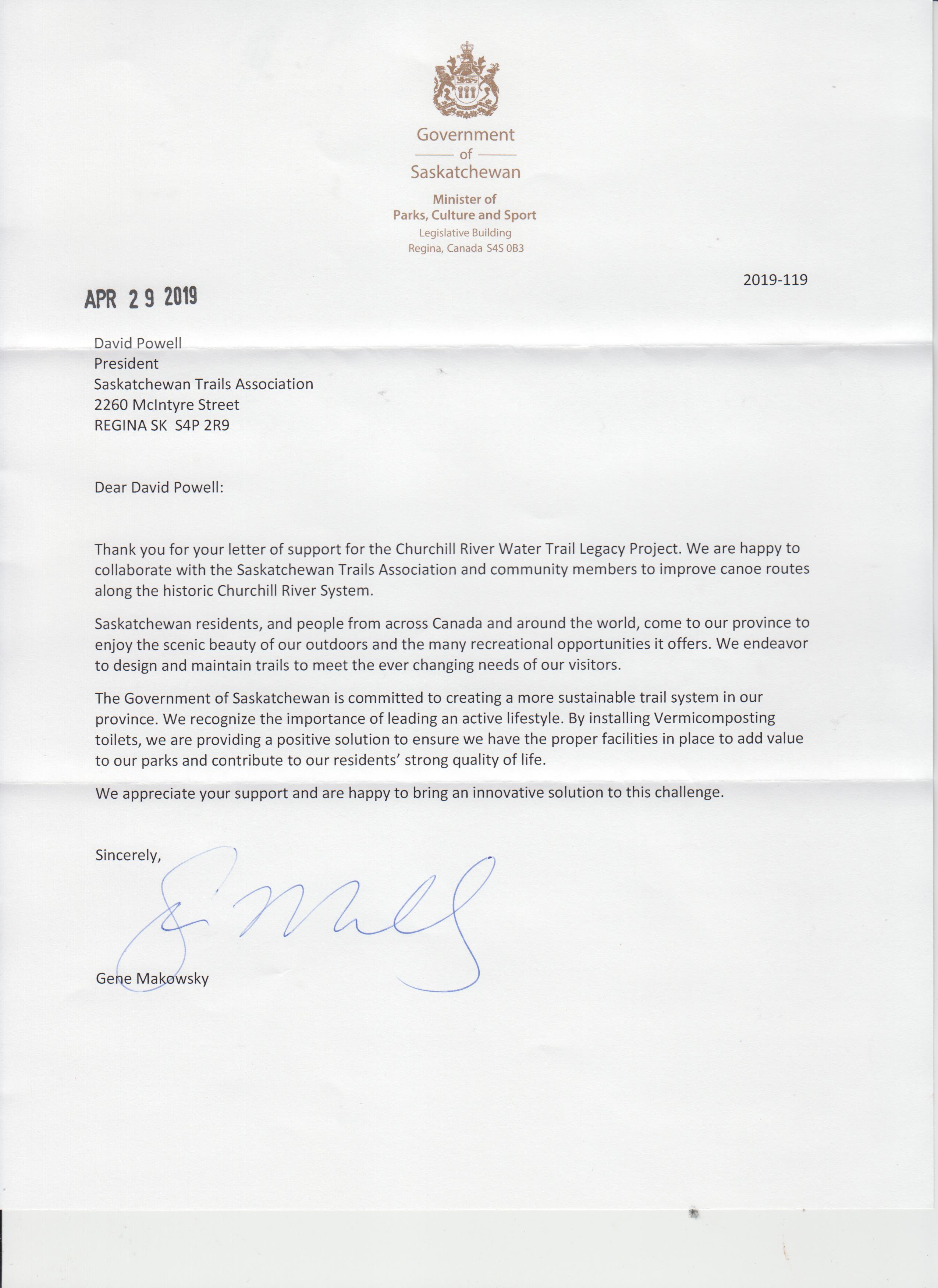
The STA also wrote a letter of support to the Minister of Parks, Culture and Sport to applaud the Churchill River Water Trail Legacy Project sustainability project that will see vermicomposting toilets installed in northern canoe routes to effectively deal with the problem of human waste.

We received the following response:

Response Letter - Churchill River Water Trail Legacy Project

How not to train for a long run in the mountains

By Russell Hodgins

  1. Travel to Saskatoon.
  2. Forget to bring your hydration pack.
  3. Also forget to bring a water bottle.
  4. Be short on time and tell yourself you can’t go pick up a bottle of fluid.
  5. Go for a long run on the amazing trails that travel along the riverbank.
  6. Be thankful that it was a cool day and then return extremely dehydrated.
  7. Drink any fluid you can find for the next 24 hours.

The run started on the paved trails at the University of Saskatchewan and very quickly, there’s an option to get off road. What followed was a series of well packed dirt trails in a rollercoaster of ups and downs. There were multiple trails so at times, I climbed up to enjoy the views and then dropped down to the river flats where I was running in the sand. The turnaround point was at the Peggy McKercher Conservation Area and just before that, is an excellent mountain bike trail that travels near the top of the river valley before dropping down and looping back closer to the river. Closer to the city, I met several people out walking their dogs along with some very courteous bike riders. Farther out, it was mostly people with backpacks getting ready for summer outings I assumed.

Image 1

Just before the Conservation Area, my wanderings had me on deer trails but the better option would have been to stay on the actual trails.

Image 2

Image 3

Image 4

Never let common sense and good judgement get in the way of a nice run! A huge thank you to the people of Saskatoon who keep these trails in such good shape.

Running the Trails in Saskatchewan

By Nicole Williams

Trail running is quickly gaining traction in the province as runners look to move off the road and into the great outdoors.

This sport involves running on any off-road surface, such as coulees, fields, forests, hills or dirt paths. The benefits include less strain and stress on your body, particularly your lower back and glutes, as you’re running on softer, more forgiving terrain than asphalt and cement. The changing landscape also increases the development of lesser-used stabilizing muscles, resulting in less repetitive movements and less risk of developing injuries that are common in road running.

Other added benefits include running in fresh air, which is better for overall lung health, and stress reduction from being away from the city, focusing less on home and work, and more on exploring the natural world around you.

Little equipment is required to get started. Road running shoes can be used; however, if you plan on spending any amount of time on the trails, you may want to buy a pair of trail running shoes. These shoes are designed to grip the softer terrain found on trails, are lower to the ground for better stability, and contain an extra layer that protects your feet from rock and other puncture wounds.

Trail runners will need to carry extra supplies with them to deal with the new challenges that comes with running off-road. You will want to invest in a comfortable, lightweight backpack to carry essential supplies such as a water bottle, bug repellent, food, sunscreen, GPS or compass with a map, a headlamp (if running at dusk or night) and basic first aid supplies like band aids.

Developing a safety strategy is a must. Before heading out on the trails, let someone know your route and when you expect to return. You should also carry a cell phone in case of an emergency, and try to run with at least one other person. You may want to join a running group, such as the Regina Road Runners Club or the Saskatoon Road Runners, for the benefit of group trail runs and events in your area.

The following are just a few of the running trails you’ll want to check out this year.

Beaver Flat 50 Course, Saskatchewan Landing Provincial Park, is one of the most grueling running trails in the province. Its 50 km course features more than 2,300 metres of vertical climbs, narrow paths, cacti, sand and wet conditions, and it boasts the appropriate hashtag: #anythingbutflat. According to the group’s website, “You’re going to love it, hate it, and love it some more. Guaranteed.”

Deadfall 50 Course, Echo Valley Provincial Park, winds through the Qu’Appelle Valley along narrow trails and expansive pastures, providing breath-taking views and challenges for runners of every level: https://deadfall50.ca

The Wascana Valley Nature Recreation Site, aka Wascana Trails, offers 15 kms of exceptional Qu’Appelle Valley trails and scenery. Trail markers lead runners through pathways that boast winding, sharp descents, steep inclines, gradual hills and other obstacles and challenges that will leave you wanting to return again and again: https://www.tourismsaskatchewan.com/search-results/105290/regina—wascana-valley-trails.

Buffalo Pound Provincial Park hosts the annual Prairie Summit Run-It Trail Race course, which features challenging hills, woodlands, and open grassland pathways, providing exceptional vistas for all trail users to enjoy: https://www.tourismsaskatchewan.com/provincialpark/303/buffalo-pound-provincial-park#sort=relevancy.

Remember, trail running is quite different from road running. You will not be able to run at the same pace on a trail as you do on a paved surface, so don’t focus on how many kilometers you’ve covered, but rather on your total time on the trails. Don’t be afraid to walk; steep inclines, rocky paths and hills are more challenging, and it’s okay to slow down and hike these areas. Falling is part of the experience, but as you get used to the off-road conditions, you will fall less. And, always be considerate to others on the trail: take out what you bring in, share the path, think of others, and don’t forget to stop and enjoy the view along the way.

Get off the beaten path; explore Saskatchewan’s running trails today!

The “Canoe Trip” Run

image001Guest blog by Russell Hodgins

What better way to fill in a couple of hours then to explore trails in a new place? Life found me in Moose Jaw on March 2nd with my running gear and time to spare so I parked on Valleyview Drive overlooking the Moose Jaw River valley. A short run down on 7th Avenue SW brought me to the trails.

It has been a frigid month with today’s wind chills in the minus 30’s, but the trails were well packed, more proof that it takes more than arctic air to keep the locals indoors. Rumor has it there is no bad weather for running, only bad clothing and I was well dressed including my old favorite balaclava. This winter has provided more than its share of cold weather to perfect the right clothing combinations. Just sayin’.

A right turn right before the bridge crosses the river put me on a trail heading south along the frozen waterway. The trail was mostly in the bush, providing some respite from the strong west winds. Deer tracks were everywhere along the trail as it went past a concrete dam and continued into Connor Park. There is a large picnic structure and other amenities in this park and I assume I would see far more people on a summer day.

The trail climbed up to the top of the valley and circled east, following the river. This led to another bridge and past that, the trail ducked back into the trees. When the path became more of a deer trail, I dropped down onto the river where it was easier going. Snowmobiles had packed the snow and the strong winds completed the job, removing any loose snow leaving a very runnable surface.

One of the things I love about our province is the abundant sunshine and today was no exception. The sun lit up the snow and the views along the river were amazing as I headed out exploring. It was well treed along both banks, the exception being places where the banks were high and too steep to allow vegetation growth.

Being on the river at the base of the tall cliffs provided a new perspective, reminding me of canoeing on other rivers. I suddenly found myself on a “canoe trip” run, eagerly running to the next bend in the river to see what I could find. In places, the river was obviously shallow with a rock garden showing above the ice, some sections were straight while others almost doubled back on itself. At one point, I came to a beaver dam across a narrow section and everywhere, deer tracks crossed back and forth over the snow packed ice. With my free time half gone, I reluctantly turned around to enjoy the view in the other direction. A different season with a canoe would have meant some upstream paddling but no worries today. Canadians walk on water for a reason.

I eventually came up off the river and into the park, finding yet another well packed trail in the trees that ran parallel to 7th Avenue and brought me back to the starting point at the bridge. On the way back, I saw two robins looking very unimpressed in a tree along the trail. I’m not sure if they were recent returns or had braved this long winter but I was happy to see them all the same and I’ll take that as the first sign of spring.